Looking Back At The June 2012 Flood That Devastated The Twin Ports And Northland 10 Years Ago
June 19 & 20, 2022 will mark 10 years since the devastating flooding that hit a large part of the Northland. Flood waters damaged homes and businesses, destroyed roadways, and carved away giant chunks of earth.
The Minnesota DNR calls the flood event the "most damaging flood in Duluth's history", surpassing an August 1972 storm that caused an estimated $12 million in damage. That 1972 flood was brought on by the area seeing about 6 inches of rain over a two week period, thoroughly saturating the ground and swelling rivers and streams. Then, on August 20, 1972, the area saw 2-4 inches of additional rain fall in a matter of a couple hours, causing significant damage.
The June 2012 flood far surpassed that 1972 event. Here's how it unfolded.
The lead-up to the June 19 & 20, 2012 Flood
As the Duluth office of the National Weather Service recalls, the week leading up to June 19 & 20, 2012 brought 2-4 inches of rain from a number of storms that swept through the region. With the ground saturated and rivers and streams swollen from the recent rains, the stage was set for the main event.
The recent rains primed the region for rain runoff and flooding issues, and a poorly-timed approaching storm system would bring record amounts of additional rain to an already saturated Northland.
Tuesday June 19, 2012 - The first day of heavy rain
A slow-moving front set up near Duluth, providing the fuel for thunderstorms that continued to develop and drop heavy rain from the Brainerd Lakes area through East Central Minnesota, the Twin Ports area, along the North Shore and into Northwestern Wisconsin.
The National Weather Service issued flash flood watches for parts of the region on Tuesday the 19th, warning of the potential of 2-4 inches of rain with some areas that could see more before the storms concluded on Wednesday.
Rainfall began across the region on Tuesday afternoon, with reports of anywhere between an inch or two of rain falling through the afternoon across parts of the region.

As evening approached, torrential rainfall moved into the Twin Ports areas and portions of the North Shore, leading to several roadways underwater. Reports of the I-35 tunnels in Duluth being flooded came in, some people were reporting manhole covers in Duluth being lifted by water, with some reportedly appearing like geysers as heavy rainwater rushed through the storm drain system.
A report of about two feet of water in Proctor, along with the following image, headlined some of the early visuals circulated around social media.
As a growing number of roadways were underwater through the evening, law enforcement in many parts of the Northland started closing roads, in some cases, no travel advisories were issued. Additional reports of knee-deep water in the Miller Hill Mall area near Wells Fargo and road damage began coming in through the later hours of Tuesday night.
The National Weather Service reported an official rainfall total for June 19, 2012 of 4.14 inches in Duluth; but it was far from over.
Wednesday June 20, 2012 - Additional heavy rain pushes into historical territory
As rain continued to fall, more reports of road damage and flooded roads continued to come in via social media in the early morning hours of Wednesday, June 20, 2012. Reports of buckled/damaged/washed-out roads in Superior, Duluth, and several other parts of the Northland along with water-covered roadways continued to come in.
In all, road closures related to the flood spanned Itasca, Aitkin, Carlton, Douglas, Southern Lake, and Southern St. Louis Counties from the flood.
During those early morning hours on Wednesday, evacuation orders were given for areas like the Fond du Lac neighborhood near the St. Louis River in Duluth and in Jay Cooke State Park as river levels continued to rise.
Reports about animals at the Lake Superior Zoo started coming out early Wednesday, including the famous image seen below of a seal that escaped during the flooding. This was one of two seals swept from their enclosures by floodwaters. Both were returned safely to the zoo. Additionally, the zoo's polar bear escaped its exhibit, but was safely returned after being tranquilized by a dart.
The area of the zoo was heavily impacted by flood waters, with roughly 2/3 of the zoo area being under water at one point some animals dying due to the flooding.
Additional evacuation orders continued to be issued for other areas through the day, including in Thomson, Carlton, Barnum, Moose Lake, and Willow River. Eventual flood damage downriver of Thomson Dam in the area of Jay Cooke State Park and along Highway 210 would become apparent, leading to a lengthy closure and reconstruction project. More on that later.
More heavy rain fell through the region through the first half of Wednesday, bringing an additional 3.11 inches of rain to Duluth's official record-keeping location, the National Weather Service office near the airport. This brought Duluth's official storm total to 7.25 inches, though parts of the city did see locally higher amounts as high as 8 to 10 inches over the two days.
Additional areas of 8-10 inches of rain were observed in the Twin Ports area, to the west of the metro, and along the North Shore, as seen in the maps below from the National Weather Service (left) and the Minnesota DNR's Climatology Office (right) below.
The highest recorded rainfall totals came from a National Weather Service volunteer observer in Two Harbors, who recorded 10.45 inches in 24 hours and a total of 10.71 inches through the course of the storm.

During the flooding, the St. Louis River at Scanlon rose 11 feet, hitting a record crest of 16.62 feet. This broke the previous record of 15.8 feet set on May 9, 1950.
Assessing the aftermath
As the rain ended on Wednesday, that was only the beginning. A state of emergency was declared in Duluth, Hermantown, Cloquet, Barnum, Moose Lake, and Superior, as roadways remained closed due to damage or being covered by water and home and business owners dealt with floodwaters in and around their properties.
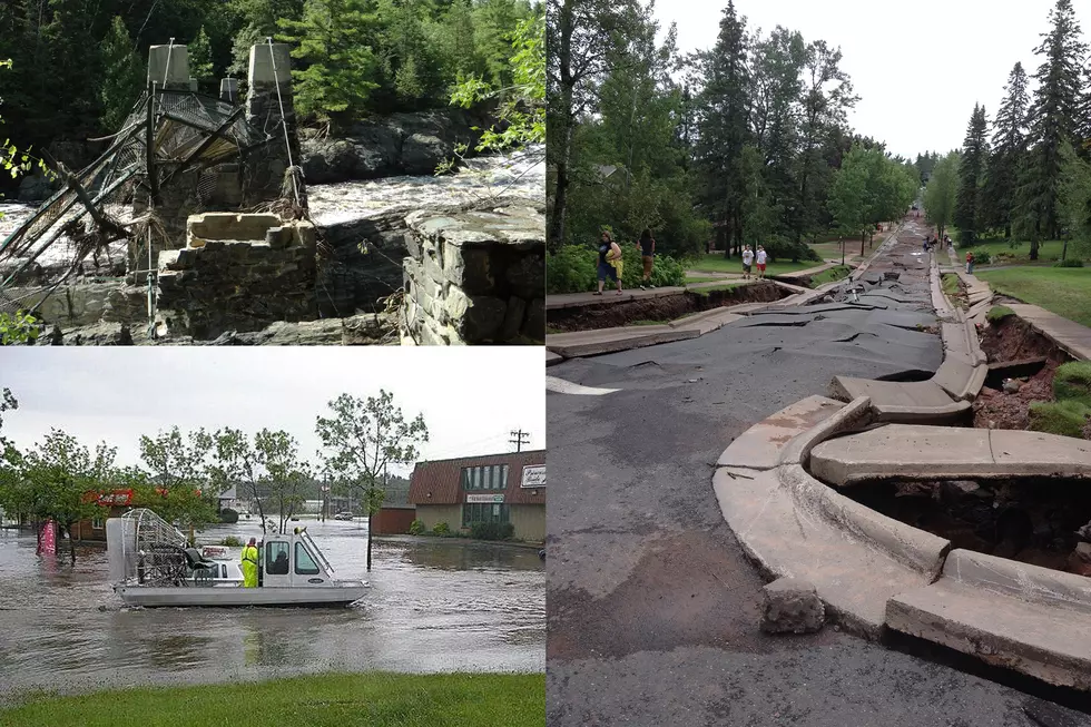
Flood damage estimates came in around $100 million. While much of the damage was directly due to the heavy rainfall and subsequent flooding around the region, Duluth's damage was further magnified by steep terrain and numerous creeks and rivers in the city. This led to washouts and buckled roads, which you can see examples of in photos below.
Some of the visuals that started coming in included watercraft cruising the water near the Miller Hill Mall area, dramatically buckled roadways along the Duluth hillside, a giant waterfall and river flowing through the zoo, and washed out roads and culverts. Damage near the Whole Foods Co-Op would lead to an eventual wall collapse. Grandma's Restaurant near the mall was surrounded by about three feet of water.
Here are some of those visuals. Tap on any photo to make it full-screen.
June 2012 Flood Aftermath
Gallery Credit: Nick Cooper - TSM Duluth
A few people opted to try to have some fun in the flood waters by playing in them, despite warnings from officials. In some cases, the concern of being swept away by fast-moving water was the key threat. For example, an 8-year-old boy was swept into a culvert while playing in the flood waters in Proctor. He was swept through the culvert for 6 or 7 blocks, but besides some scrapes, was unharmed. Separately, concerns about sewage in the flood water were also issued, yet some opted to kayak or jet-ski in the water near the Miller Hill Mall.
Social media was full of pictures and videos. Among them, this one showing the swollen St. Louis River in the Scanlon area, where I-35 and Highway 61 cross the river.
A car that was left in a crater from water washing away the roadway around it:
Along with one of many sinkholes. This one near Superior High School:
And one of several people that had their car submerged by flood waters:
Among the vast damage left behind was that of the area of Jay Cooke State Park, as the St. Louis River severely damaged the swinging bridge carved away portions of the river bank and of Highway 210 through the park. Two major points of damage along Highway 210 left the road closed for 5 years, reopening in the fall of 2017.
Someone captured and shared a photo of the water as it ripped through the swinging bridge structure, mangling the metal and cabling.
The park was left closed by road damage, coming at two main points. The first major damage point was just west of the visitor center, sweeping away 175 feet of roadway, leaving a hole 45 feet deep. The other location, just east of the visitor center, left a hole where Highway 210 once stood that was 1,000 feet wide and 100 feet deep. Additionally, portions of the Munger Trail were damaged from the flood. The Minnesota DNR organized a media tour of the flood-damaged area, which you can see more about here.
You can see photos of the damage at Jay Cooke below. Tap on any photo to make it full-screen.
Jay Cooke Damage From 2012 Flood
Gallery Credit: Nick Cooper - TSM Duluth
In the subsequent years, the region has mostly recovered. In some cases, it took several years. Even then, reminders are still left by this historic flood. Some homeowners and businesses had a long path to recovery. It took years in some cases to get certain roads usable again. Scars from flood waters along rivers and streams remain, albeit regrown with vegetation. While it has been 10 years, this is an event that will not soon be forgotten.
More From B105