
How Much Are We Getting?! Huge Updated Snowfall Predictions For Minnesota Storm
If the hype behind the size of this snowstorm targeting Minnesota in the next few days ends up becoming true, it is going to be a really messy end to March.
The National Weather Service has been throwing out potential snowfall totals from this storm in their predictions that could more than double the amount of snow some places have gotten across Minnesota, all falling in just a couple of days!
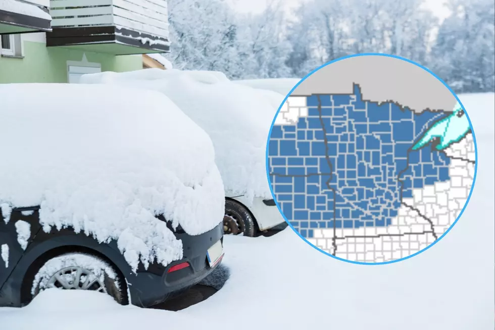
In anticipation of this big snowstorm, nearly all of Minnesota has been put under a winter storm watch. Of the 87 counties in Minnesota, only a handful along the southern border are not under a winter storm watch for this weekend's storm.
There have been a large variety of snowfall totals being predicted for around the state, but as the storm gets closer, a clearer picture of how much snow could fall is starting to develop.
What's the timing of this storm?
Snow is expected to spread into the region overnight Saturday into Sunday, with Southwestern Minnesota starting to see snow in the early morning hours, the Brainerd area seeing snow starting between 8-10 am on Sunday, Duluth seeing snow start between noon and 2 pm on Sunday, and the border country seeing snow starting in the early evening hours on Sunday.
The heaviest of the snow is expected in the later hours of Sunday and into Monday, with some parts of the region seeing a chance of a rain-snow mix on Monday and into Tuesday. Temperatures will cool to see the system move out with light snow in the later part of Tuesday before snow wraps up.

Here's how much snow the National Weather Service says Minnesota towns will get
There are still some variables that could impact snow totals, but we're starting to get a clearer picture of what to expect from this storm.
The Duluth office of the National Weather Service published some predictions in their noon update on Friday, painting a path of up to nearly 2 feet of snow through a portion of Central Minnesota up along the North Shore.
READ MORE: Solar eclipse viewing guide for Minnesota towns
Areas along the North Shore from Duluth northward could also see blizzard conditions as strong wind combines with the snow to make for blowing snow, difficult travel and potential power outages.
At the heart of the storm's heaviest snow path are cities like St. Cloud, Brainerd, Hinckley, Duluth, Two Harbors, and Silver Bay, where up to around 2 feet of snow could fall. Areas to the north and south of that could still see from 6 to 15 inches of snow in places like Walker, Grand Rapids, and Grand Marais. A pocket of potentially heavier snow could develop in Southwestern Minnesota, with over 2 feet of snow possible if temperatures stay cold enough to allow that to happen.
Once the storm wraps up, we won't see a major warm-up. Temperatures look like they will stay in the 30s in the days following, with another chance of lighter snow at the end of next week. So, if your hope was just to "let it melt", that probably won't be the the best plan.
Snowiest Cities & Towns In Minnesota
Gallery Credit: Nick Cooper
More From B105
![Famous Poseidon House In Minnesota Is Remodeled + For Sale Again [GALLERY]](http://townsquare.media/site/150/files/2024/04/attachment-Untitled-design-111.jpg?w=980&q=75)
