
Minnesota Brushed by 1-in-100 Year “Heat Dome” Next Week: Where Will it Feel Like 110F?
Sorry Bill Shakespeare, but now is the summer of our discontent, well at least over the southern and western part of the USA, which has seen suffocating heat and humidity. A heat index of 128F in Tampa? 107F in Portland, Oregon, where a majority of residents don't have air conditioning. A record 119 days of 90+ highs at Ft. Myers, Florida - more than Phoenix?
Ask a friend or family member living in the south, or more recently, the Pacific Northwest. They will probably agree that it has been a miserable summer.
And not to be left out, portions of Minnesota and Wisconsin will experience some of that hot, muggy misery early next week as a massive "heat dome" sets up over the Midwest.
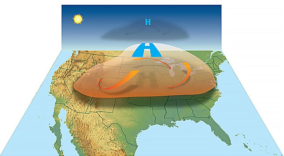
What on Earth is a heat dome? According to NOAA this happens when strong, high-pressure atmospheric conditions create vast areas of sweltering heat that gets trapped under the high-pressure "dome." It's too hot and dry underneath that dome for T-storms to pop up, so there is little or no rain to cool things off.
Weather models, including ECMWF (the "European model" above) suggest that next week's heat dome may be a 3 Sigma Event, meaning something like this happens roughly once a century. We'll see, but there's little doubt it's going to get STINKING HOT across much of the central USA next week.
Once again the Northland will be saved by cooling winds circulating off Lake Superior, but western and southern Minnesota will probably bear the brunt of any heat, with a heat index (what it feels like factoring temperature and dew point) of close to 110F late Monday over western and southwestern Minnesota.
The Twin Ports will see flashes of heat next week with a string of 80s, possibly low 90s well inland, but winds blowing off Lake Superior should take the edge off the heat.
The Twin Cities may pick up 4-5 days in a row of 90s, with a chance of mid and even upper 90s Monday and Tuesday before things cool off (a little) late next week.
SEE ALSO: Does Sweating Corn Contribute to Humidity?
But yes, it does look like a hot, humid start to the Minnesota State Fair this year. I see a few 90s-on-a-stick in 2023, just like most summers.
This could be an historic heat wave for parts of southern/western Minnesota, Iowa and Missouri, with the worst of the smothering heat and humidity passing just to our south.
No need to pack away the shorts and T-shirts anytime soon.
15 Very Minnesota Ways To Keep Cool During the Heatwave
Gallery Credit: James Rabe
More From B105
